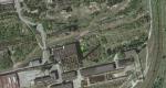
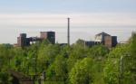
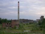
RU M 10X/2
Huta Kościuszko, Metalowców, Chorzów, Polsko

| General data: | |
| Class: | RU (Rizistropic ulhorf) |
| Height: | 10X m |
| Gallery: | 2 |
| Type: | M (Monolitic concrete) |
| Gallery: | 2 |
| Detail: | 0 (Circular profile) |
| Bilighorze: | HD (Ladder with full-protection) |
| Status: | P |
| Country: | POL (Polsko) |
| (p)Region: | SL (Śląskie) |
| Municipality: | Chorzów |
| Coords: | 50°18'7.996"N,18°57'46.145"E |

Record history:
| 15.2.2012 22:00:02 |
|
Mc - Prekioarcheologie |
Map + photo
 |
 |
 |
 |
KODA © M.i.X 2008-2024 - CZ