
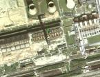
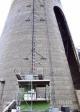
| General data: | |
| Class: | GU (Globonic ulhorf) |
| Height: | 3XX m |
| Gallery: | 7 |
| Type: | M (Monolitic concrete) |
| Gallery: | 7 |
| Detail: | 0 (Circular profile) |
| Grounds: | A263 |
| Status: | P |
| Country: | DEU (Německo) |
| (p)Region: | SN (Sachsen) |
| Municipality: | Boxberg/Oberlausitz |
| Coords: | 51°24'56.938"N,14°34'0.048"E |
| Details (CZ): | 4 display >> |

Record history:
| 14.10.2012 21:23:40 |
|
Mc - prekioarcheologie |
| 15.10.2012 20:24:25 |
|
starbreaker - přiřazení do areálu |
Map + photo
 |
 |
 |
 |
 |
 |
 |
 |
Poznámky
KODA © M.i.X 2008-2024 - CZ
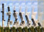
Video z odstřelu: