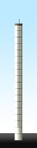
| General data: | |
| Class: | LT (Lystecit trepariozom) |
| Height: | 28 m |
| Gallery: | Ub (Wretch / no gallery) |
| Count: | 3T (Tight multistack) |
| Type: | S (Concrete segments) |
| Gallery: | Ub (Wretch / no gallery) |
| Detail: | 0 (Circular profile) |
| Bilighorze: | 3HC |
| Status: | P |
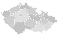
| Country: | CZE (Česká republika) |
| (p)Region: | PHA (Praha) |
| County: | 5 (Praha 5) |
| Municipality: | Radotín |
| Coords: | 49°59'45.8"N,14°20'28.9"E |

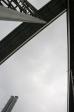
Map + photo
 |
 |
 |
 |
KODA © M.i.X 2008-2024 - CZ